Circle Line Stages 1 & 2
-
Is not really stage 5, but its stage 6
-
Originally posted by sgbuses:
Why draw all over again when someone else has done it for you!

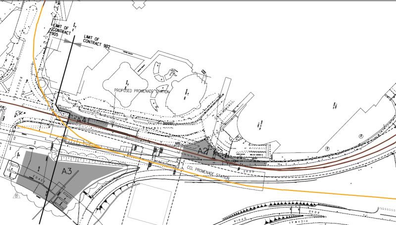
CCLe and DTL tunnels run parallel under the river and are already completed! (DTL1 newsletter/no. 10) The diagram in the newsletter is specific; CCLe left and DTL1 on the right.
You might think it does not make sense for Circle Line (Marina branch) and Downtown Line to run parallel. But during planning, they would have considered
(1) saving the pain of passengers having to change around again at Promendae since both lines are heading to different ends of the island OR/AND
(2) do a Raffles Place style track swtiching, since Bayfront would be the middle of the Downtown Line (if you take Stage 3 into consideration).I have seen it before, but at first I do not comprehend the graphics. But thanks anyway :D
Given from what you have posted, it seemed that although the other side of CCL Promendae platform is also another unused platform, which the forumers here know, but the verdict is it is a useless platform for a very long time. Sad.....
-
Using diagrams provided by Samuel Lee, sgbuses and some of my personal observations, I have deduced the following track diagram:
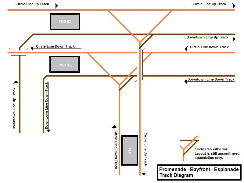
Notes: Up Lines and Down Lines are provided as reference according to the direction of train travel and may or may not relate to the actual track diagram. Track diagram does not include ATP blocks. Bugis and Bayfront stations are not drawn in as I have not seen the actual track diagrams and geographical layout if it yet.
-
Originally posted by NickLim™:
Using diagrams provided by Samuel Lee, sgbuses and some of my personal observations, I have deduced the following track diagram:

Notes: Up Lines and Down Lines are provided as reference according to the direction of train travel and may or may not relate to the actual track diagram. Track diagram does not include ATP blocks. Bugis and Bayfront stations are not drawn in as I have not seen the actual track diagrams and geographical layout if it yet.
To NickLim: Nice effort, but, not meant to offend you, that the diagram is incorrect, given the sgbuses' LTA map shown a marking of A4 is "Proposed Promendae Station", this shown clearly, that DTL station cannot be at the same spot as CCL, as if it is a City Hall or Raffles Place.
But, if your DTL is drawn below than the CCL (B4 or even B5), and put the DTL Promendae station on the right, I believe, chances are, you have got it right.
-
I have many doubts, especially on the directions of the tracks.
I believe the two new built platforms are meant for the CCL extension. But this design would mean that the train from CCLE would have to intersect on the current CCL track. Am I right to say that two new platforms have no link towards the Stadium?
I wonder why the CCL is designed to stop at the current platforms, and not at the unopened platforms. Is it because of the sharp turning? If that's the case, the assume CCLE have to intersect.
Based on the plan sgbuses has put up, that new and unused platforms is definitely not for Downtown line because of the distance of the stations, and another reason is the different type of tracks.
-
Originally posted by Samuel Lee:
To NickLim: Nice effort, but, not meant to offend you, that the diagram is incorrect, given the sgbuses' LTA map shown a marking of A4 is "Proposed Promendae Station", this shown clearly, that DTL station cannot be at the same spot as CCL, as if it is a City Hall or Raffles Place.
But, if your DTL is drawn below than the CCL (B4 or even B5), and put the DTL Promendae station on the right, I believe, chances are, you have got it right.
It's possible. From what I observed while travelling from Esplanade to Nicoll Highway, the current track do not meet with the unused tunnel after Promenade station. This means that the tunnel just ends there, or curves left. If DTL will use a new station, this means that this is a shuttle platform with a buffer at the end, as I have predicted and posted in my Facebook album.
With this edit, please ignore the left turn after Promenade station towards Bugis, and use the brown lines as the Promenade - Marina Bay shuttle line.
-
Originally posted by sbs&tibs:
I have many doubts, especially on the directions of the tracks.
I believe the two new built platforms are meant for the CCL extension. But this design would mean that the train from CCLE would have to intersect on the current CCL track. Am I right to say that two new platforms have no link towards the Stadium?
I wonder why the CCL is designed to stop at the current platforms, and not at the unopened platforms. Is it because of the sharp turning? If that's the case, the assume CCLE have to intersect.
Based on the plan sgbuses has put up, that new and unused platforms is definitely not for Downtown line because of the distance of the stations, and another reason is the different type of tracks.
Yes, the 2 new tracks have no link to Nicoll Highway and Stadium stations.
I suppose it's because of the maximum turning radius of the train. CCLE will intersect the current line due to this. However, this is not uncommon in other countries eg. London Underground and New York Sunway.
Hmm... What do you mean by different type of tracks? All railways here uses Standard Gauge.
-
Originally posted by sbs&tibs:
I have many doubts, especially on the directions of the tracks.
I believe the two new built platforms are meant for the CCL extension. But this design would mean that the train from CCLE would have to intersect on the current CCL track. Am I right to say that two new platforms have no link towards the Stadium?
I wonder why the CCL is designed to stop at the current platforms, and not at the unopened platforms. Is it because of the sharp turning? If that's the case, the assume CCLE have to intersect.
Based on the plan sgbuses has put up, that new and unused platforms is definitely not for Downtown line because of the distance of the stations, and another reason is the different type of tracks.
I can assume and assure that there are no link from Nicoll Highway to Promendae via the new and unopened platforms.
-
Originally posted by NickLim™:
Yes, the 2 new tracks have no link to Nicoll Highway and Stadium stations.
I suppose it's because of the maximum turning radius of the train. CCLE will intersect the current line due to this. However, this is not uncommon in other countries eg. London Underground and New York Sunway.
Hmm... What do you mean by different type of tracks? All railways here uses Standard Gauge.
I mean different rails, for eg, CCL trains cannot run on NEL tracks? -
Originally posted by sbs&tibs:
I mean different rails, for eg, CCL trains cannot run on NEL tracks?The reason why CCL trains cannot run on NEL, is becoz of the power supply used is different. CCL uses 3rd rail, just like EWL / NSL while NEL is the so far only Singapore MRT uses pantographs.
BTW, even if you managed to steal / manufactured a C151 train, and you can attempt to fit into NEL tracks, becoz they are standard gauges. But due to NEL does not have 3rd rail, so the C151 cannot move. Of course, you can put a C151 onto CCL, and most likely can drive it, but dangerously under manual mode (Due to different security systems used)
-
Originally posted by Samuel Lee:
The reason why CCL trains cannot run on NEL, is becoz of the power supply used is different. CCL uses 3rd rail, just like EWL / NSL while NEL is the so far only Singapore MRT uses pantographs.
BTW, even if you managed to steal / manufactured a C151 train, and you can attempt to fit into NEL tracks, becoz they are standard gauges. But due to NEL does not have 3rd rail, so the C151 cannot move. Of course, you can put a C151 onto CCL, and most likely can drive it, but dangerously under manual mode (Due to different security systems used)
Can C751A put in CCL tracks?
-
Originally posted by c751bLoVuR:
Can C751A put in CCL tracks?
Such questions I did asked before on Questions thread.
So yes, C751A can put into CCL tracks, but it cant move, becoz no pantographs in CCL.
-
Okay, just finished redrawing the diagram. With a buffer at the end of the track, it should look something like this.
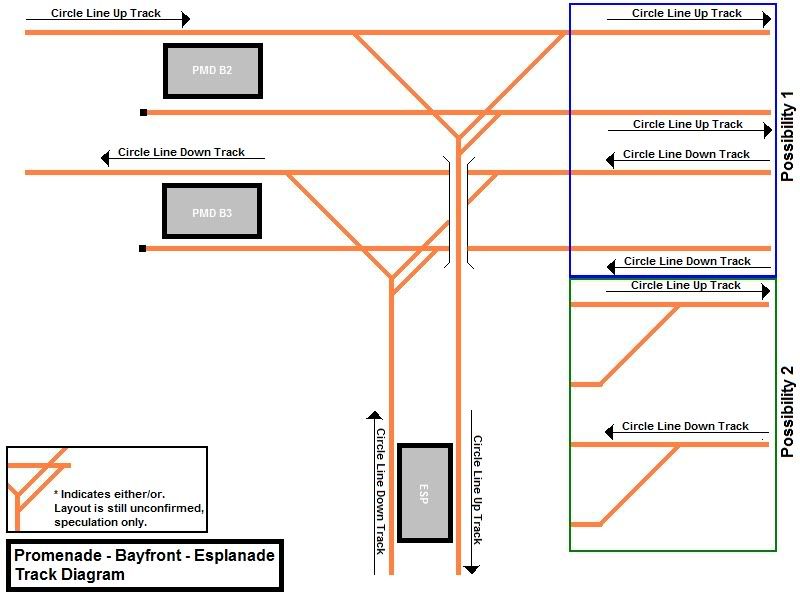
To the trained eye, you'll see that this idea makes no sense at all as the shuttle trains would have to either consolidate services to 1 level of the station, or have alternate trains arriving at alternate platforms (a la JEMP).
I have decided to extend the overrun to allow alighting on B3 and boarding on B2. This is to allow passengers going in the same direction ease of transfer. This might also be the actual case since the tunnel seems to turn left after Promenade. (Anyone with a video of the ride between Esplanade and Promenade can help me with this haha.)
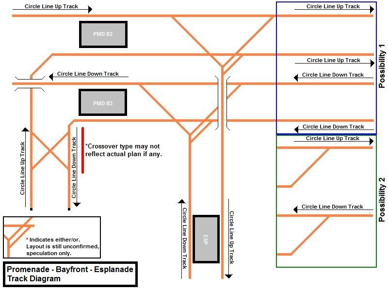
This method is widely used in Hong Kong as most of the line's terminals are also interchanges.
With this, should Stage 6 pop up (HarbourFront to Promenade), the shuttle train going towards Dhoby Ghaut would go towards Bayfront and Marina Bay instead of Promenade as believed.
-
Originally posted by NickLim™:
Actually it's for CCL Extension to Bayfront and Marina Bay. DTL may be a seperate station.
Makes sense too. But its gonna be quite chaotic and slightly confusing this way.
I personally feel that DTL is going to have another platform, due to planning. You see ar, they would have planned for the station ages ago and definitely should not have planned for the CCL-DTL thingy, so what I said firstly should have been wrong. Of course, as a commuter, I would be glad if they did it in the CTH manner, but its just very hard as they are using 2 different models of trains, that are so far unlikely to crossover to the other line, as I believe the specifications, the signals and some of the new technologies may not match, so if the track were to be shared, it would be quite confusing.
-
http://www.channelnewsasia.com/stories/singaporelocalnews/view/1047842/1/.html
Circle Line's daily ridership expected to hit 200,000 with opening of new stations
-
Originally posted by NickLim™:
Using diagrams provided by Samuel Lee, sgbuses and some of my personal observations, I have deduced the following track diagram:

Notes: Up Lines and Down Lines are provided as reference according to the direction of train travel and may or may not relate to the actual track diagram. Track diagram does not include ATP blocks. Bugis and Bayfront stations are not drawn in as I have not seen the actual track diagrams and geographical layout if it yet.
DTL and CCLe won't interact. Most probably they'll both have different signalling technologies, which makes it incompatible for cross-running.
-
Originally posted by NickLim™:
Okay, just finished redrawing the diagram. With a buffer at the end of the track, it should look something like this.

To the trained eye, you'll see that this idea makes no sense at all as the shuttle trains would have to either consolidate services to 1 level of the station, or have alternate trains arriving at alternate platforms (a la JEMP).
I have decided to extend the overrun to allow alighting on B3 and boarding on B2. This is to allow passengers going in the same direction ease of transfer. This might also be the actual case since the tunnel seems to turn left after Promenade. (Anyone with a video of the ride between Esplanade and Promenade can help me with this haha.)

This method is widely used in Hong Kong as most of the line's terminals are also interchanges.
With this, should Stage 6 pop up (HarbourFront to Dhoby Ghaut), the shuttle train going towards Dhoby Ghaut would go towards Bayfront and Marina Bay instead of Promenade as believed.
LTA has a few different versions of the maps over the years. I just went back to restudy the diagrams (which were from SkyscraperCity), and I think Nick's current one is more likely.
This one makes for particularly interesting reading :

-
Originally posted by sgbuses:
LTA has a few different versions of the maps over the years. I just went back to restudy the diagrams, and I think Nick's current one is more likely.
This one makes for particularly interesting reading :

Those in colour has been added on by someone else. So the CCL1 and CCLe configuration can be re-arranged in any manner, if the track formation allows so.
4 levels of platforms.Too bad the area below the CCL station has been piled up, if not the DTL1 platform would face the piling area, to facilitate transfers in short distances.
-
Do anyone has an illustration of the tracks between Tai Seng and Bartley? Thanks.
Yeah, at first I thought Paya Lebar's middle track would spilt towards Dakota. I think the middle track will supplement the between Paya Lebar to Serangoon or Bartley during peak periods. There is quite a demand along that stretch.
-
Originally posted by sbs&tibs:
Do anyone has an illustration of the tracks between Tai Seng and Bartley? Thanks.
Yeah, at first I thought Paya Lebar's middle track would spilt towards Dakota. I think the middle track will supplement the between Paya Lebar to Serangoon or Bartley during peak periods. There is quite a demand along that stretch.
I'll see if I can draw out 1 after dinner.
-
Originally posted by sbs&tibs:
Do anyone has an illustration of the tracks between Tai Seng and Bartley? Thanks.
Yeah, at first I thought Paya Lebar's middle track would spilt towards Dakota. I think the middle track will supplement the between Paya Lebar to Serangoon or Bartley during peak periods. There is quite a demand along that stretch.
Oops sorry, I read it as Paya Lebar.
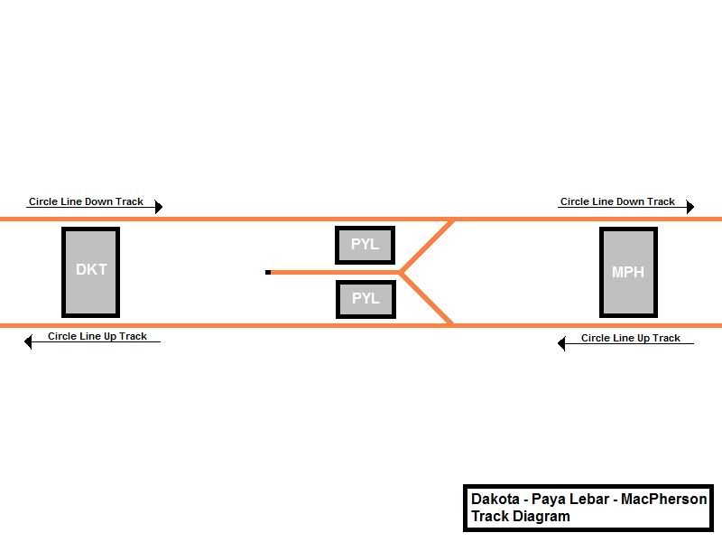
Tai Seng to Bartley, I only have a rough idea. But I think Samuel Lee has one.
-
i believe the third track at paya lebar is for the marymount-paya lebar service.
-
Originally posted by sgbuses:
LTA has a few different versions of the maps over the years. I just went back to restudy the diagrams (which were from SkyscraperCity), and I think Nick's current one is more likely.
This one makes for particularly interesting reading :

this is actually a diagram made by me over at SSC.
anyway further discussions on that side has proven that the CCLe platform indicated here is unlikely to materialise.
this is because the current Promenade platforms in service now has a Y-shaped split to serve both the CCLe and CCL1 towards Esplanade. and if the currently unused platforms are to serve CCLe, this makes the segment a level junction (see http://en.wikipedia.org/wiki/Level_junction), which LTA has been trying to avoid.
the final nail in the coffin would be that these platforms were originally designed to serve the then-Bukit Timah Line (BTL, now DTL2). this original provision is destroyed along with the Nicoll Highway collapse. this also resulted in the DTL1 (back then the CCL Downtown Extension) interchange shifting from Nicoll Highway to Promenade, resulting in the current plans we see in the picture above.
this CCLe platform indicated above will thus never serve DTL1 as well, since the DTL Promenade station is already under construction as we are discussing here and is probably of incompatible signalling.
because of historic reasons, what will most likely happen is that CCLe and the CCL1 services will share the current two platforms.
-
Originally posted by deskoh91:
this is actually a diagram made by me over at SSC.
anyway further discussions on that side has proven that the CCLe platform indicated here is unlikely to materialise.
this is because the current Promenade platforms in service now has a Y-shaped split to serve both the CCLe and CCL1 towards Esplanade. and if the currently unused platforms are to serve CCLe, this makes the segment a level junction (see http://en.wikipedia.org/wiki/Level_junction), which LTA has been trying to avoid.
the final nail in the coffin would be that these platforms were originally designed to serve the then-Bukit Timah Line (BTL, now DTL2). this original provision is destroyed along with the Nicoll Highway collapse. this also resulted in the DTL1 (back then the CCL Downtown Extension) interchange shifting from Nicoll Highway to Promenade, resulting in the current plans we see in the picture above.
this CCLe platform indicated above will thus never serve DTL1 as well, since the DTL Promenade station is already under construction as we are discussing here and is probably of incompatible signalling.
because of historic reasons, what will most likely happen is that CCLe and the CCL1 services will share the current two platforms.
So you trying to say that the platforms behind those walls will never be used or what? What a waste.
-
So I'm guessing that CCLe will be a Marina Bay to Paya Lebar shuttle?